Home|Resources|Kirklees Local Cycling and Walking Infrastructure Plan
Kirklees Local Cycling and Walking Infrastructure Plan
Local Cycling and Walking Infrastructure Plans (LCWIPs) are a new approach to improving walking and cycling within local areas. This is a summary of the proposals we have developed during the initial pilot phase of developing the Kirklees LCWIP.
Phase One aimed to test our approach and our tools through looking at two very specific geographic areas in the district; one looking at a cycling route in east Huddersfield and the other assessing walking improvements in Dewsbury town centre. The proposals have been developed through workshops with key stakeholders, street audits, data analysis and technical assessments of potential improvements. Further stakeholder engagement was undertaken in winter 2019 to get feedback on the proposals.
We are now taking the LCWIP process into the next phase and look to build upon the work done in this initial pilot. We’ll be looking at key cycling routes and walking areas across the district and assessing what improvements we can make to make these active travel modes both safer and more attractive. This will include everything from improving the quality of our pavements to building new pedestrian crossings and protected cycle routes. The LCWIP proposals, like those identified during Phase One, will be identified ahead of funding being allocated meaning that as money becomes available we will know how and where we can best spend it to make the biggest improvements. In this way both the Phase One Kirklees LCWIP pilot and the next stage we are starting now inform and support our Connectivity Infrastructure Plan for the region, which sets out the 20-year transport infrastructure investment programme in West Yorkshire.
A more detailed Phase One Kirklees LCWIP report is available that explains the analysis carried out to identify the improvements proposed as well as high level network concepts for cycling and walking in the geographic areas of focus.
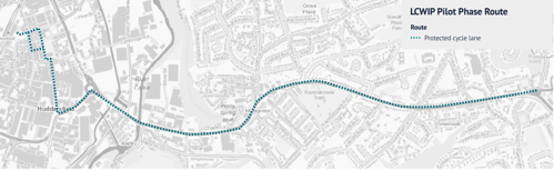
Proposed cycle route improvements for east Huddersfield
A range of cycle routes into Huddersfield were identified and prioritised as a result of data analysis and stakeholder feedback. A route into the town centre from the east which could form the base of a future network was assessed in more detail to establish how we could create high-quality cycle provision on this corridor. By high-quality cycle provision we mean routes that make cycling safer and more pleasant, and routes that are suitable for a range of users including schoolchildren and the elderly as well as all types of cycle, including adaptive and cargo bikes. The process of route prioritisation is described in the detailed phase one report for the Kirklees LCWIP.
A single potential route alignment was identified, as depicted in the map below. Further work will need to be carried out to ensure that the outline design shown here can be achieved to the requisite standard. Further links which will connect these routes to other communities to widen access and link to other parts of the district will be considered during future stages of LCWIP development.
We will also consider complementary measures such as waiting/loading restrictions and improved landscaping, lighting and public realm. In order to make accessing the cycle routes safer we may need to consider re-routing or limiting through traffic on certain roads to create safer streets, which will provide further benefits for local communities such as better air quality and reduced noise pollution.
We will also look at programmes to support the proposed improvements, including providing access to bikes or enabling behaviour change. These complementary measures would be defined as and when we take schemes further forward, including at further stages of the LCWIP process.
This map highlights the route proposed for a protected cycle lane in east Huddersfield
Proposed walking improvements for Dewsbury town centre
We undertook a community street audit which allowed local stakeholders to provide feedback on the local walking environment, with a follow-up workshop. This identified a number of potential improvements for the town centre which would make walking, visiting or shopping in Dewsbury more pleasant and attractive. Options we looked at included widening pavements, narrowing side-roads and new crossing facilities. Further detailed feasibility and design work will need to be carried out at a later stage, informed by this initial list of options. We will also look at improving the local environment and public realm across other areas of Dewsbury, building out from this initial study.
These proposed improvements to our public realm could also be accompanied by a range of complementary measures which would be defined in the next stages of LCWIP development. Some identified complementary measures which have worked elsewhere include new or better enforced waiting/loading restrictions, restrictions to general traffic and improved landscaping, lighting as well as the provision of accessible seating. The report available here includes further details of the proposed improvements, the approach taken to identify the improvements for Dewsbury, as well as an indicative walking Network Map for the town, showing the main routes for walking, and other important pedestrian routes.
The principles for good walking infrastructure used to help identify the improvements needed are also included in the report.
Improvements across the area
Install LED lighting across the area and on main pedestrian routes into town centre.
Improving all ring road pedestrian crossings – with single stage crossing, narrowed vehicle lanes to provide wider pavements, and wider refuges where crossings require more than one stage.
Install pedestrian wayfinding signage at all main decision points, with walking times.
Reduce and rationalise street clutter, as well as small scale improvements such as dropped kerbs, removal of footway obstructions.
This includes
Update zebra crossing between Mecca bingo and retail units, with continuous pavement crossings over car park accesses.
Upgrade subway between Railway Street and Longcauseway.
Remove traffic from southern section of Northgate to create traffic-free route north-south through town centre.
Remove traffic from Northgate Road and inner section of Halifax Road to create pedestrianised space around Pioneer Square.
Reduce width of junction to supermarket in Batley Carr, with continuous pavement crossing.
Install signalised pedestrian crossing and zebra crossing at site of current informal crossing on A638 Halifax Road.
Improving access to station and local environment for pedestrians on Eightlands Rd, with better LED lighting, improvements to play area and continuous, repaired pavement.
Realign pedestrian access to bus station, with zebra crossing providing direct access to bus station from Southgate.